Recent investigations such as those from The Guardian and studies such as those from Haya et al. (2023) and West et al. (2023) have unveiled that a significant portion of forest carbon initiatives lacks transparency and is of questionable quality. This has prompted industry stalwarts like Scott Kirby, the CEO of United Airlines, to ponder if the entire nature-based carbon industry might be a “fraud”. However, “climate change is not fixing itself”, as Elias Ayrey of Renoster so eloquently puts it. Ayrey believes that it is unwise to completely discard what may be our primary practical solution to carbon emissions. We should deal with it, he contends, by cleaning up the space and ousting the dishonest players. It is hard to disagree.
Many point out that there’s a pressing need to enhance the trustworthiness and quality of the forest carbon market. Steps towards this include ensuring:
- Project Implementation Quality: ensuring carbon offsetting projects have a lasting positive effect on biodiversity and local communities.
- Fair Benefit Sharing: Enhancing carbon credit price transparency and ensuring fair distribution of benefits. As of 2022, BFA Global revealed that most profits were taken by intermediaries and not the local communities.
- Geo-transparency: Using satellite imagery and data for monitoring and verifying project impact.
The quality of project implementation and equitable distribution of benefits depends on the operational and ethical standards of both implementers and intermediaries. These standards can be gauged through multifaceted assessment methods. Mentioned below are some of the specialized rating and verification service providers in this domain:
Rating:
Geospatial transparency means disclosing exact locations and related satellite and drone imagery that is collected at regular intervals. It should be possible to analyze collected geospatial data for changes in variables of concern, such as forest cover, biomass, fire, and biodiversity.
Numerous specialized firms and startups provide advanced Monitoring, Verification, and Reporting (MRV) solutions to mitigate risks associated with carbon forest projects. Below is a curated list, categorized by their areas of expertise:
Biodiversity:
Biomass:
Fire:
Enhanced geo-transparency can be realized by integrating diverse data and information sets. Projects reveal their geo-locations using detailed drone and satellite imagery over time and complement these visuals with remote sensing data products. By transparently sharing project impacts, advancements, and hurdles, the examples below illustrate how various data sources can provide a more holistic understanding of the quality and progress of a nature-based project.
Permanence of nature-based carbon sequestration
The Carbono Bio Registry, spearheaded by Grupo Ecológico Sierra Gorda I.A.P, harnesses geospatial forest loss tracking. Integrated with monthly satellite time series from NICFI, this system vigilantly monitors the sustained impact of biodiversity restoration projects in Querétaro, Mexico. Check out the project.
Restoration success of wildlife corridors
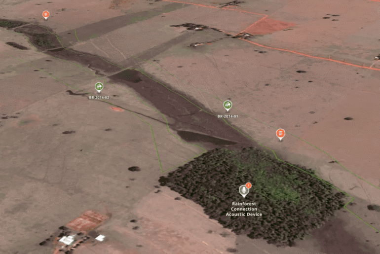
WeForest and IPE oversee the monitoring of restoration advancements in the wildlife corridors of the Pontal project in Brazil. They utilize high-resolution satellite time series from Planet to keep tabs on tree cover regeneration. To capture the rejuvenating impact on biodiversity, they employ camera traps and bioacoustic instruments provided by Rainforest Connection. Check out the project.
Reforestation time-series
The European forest industry suffered a significant blow from bark beetles. In mere weeks, entire stretches of forest were felled due to these infestations. This crisis prompted the planting of newer, more climate-resilient tree species. Using Esris’ Wayback high-resolution satellite time series, one can virtually monitor the progress of reforestation, witnessing the forest’s regrowth over time. An example of this is a forest in Belgium that underwent reforestation.
Documentation of regreening techniques
The Wyss Academy for Nature has documented passive regeneration efforts in Kenya. Techniques like the construction of semi-circular bunds have been introduced to enhance water retention and promote the penetration of water into deeper layers, ensuring greater water availability for revitalizing vegetation. By overlaying high-resolution drone imagery atop satellite base maps, one can vividly capture both the earthwork and the regreening advancements. Check out the project.
We’d love to hear your thoughts on boosting geo-transparency! Let’s chat and explore ways to enhance geo-transparency within your project. Our goal? To foster genuine, trust-based relationships with your stakeholders.


